( 8" More Fell After This Photograph )
Snow Depth At 1:35 PM on February 21, 2015
Mean Depth In High Chaparral of High Knob Massif

Photograph by Darlene Fields - © All Rights Reserved.
The mean snow depth reached 36" in High Chaparral during evening hours of February 21, with up to 40"+ on northern slopes in the main crest zone of the High Knob Massif.
The mean snow depth reached 36" in High Chaparral during evening hours of February 21, with up to 40"+ on northern slopes in the main crest zone of the High Knob Massif.
The High Knob Landform
The High Knob Landform WebCite Permalink
The Appalachian Climate Center
Following a snowy opening to Winter 2014-15, during the month of November, a snow drought developed across the southern Appalachians with much below average snowfall observed during the typically snowy months of December & January.
First Significant Winter Storm of 2014-15 Season
That all began to change during February.
February 16, 2015 At 5:06 PM
Looking Toward High Knob Massif
University Of Virginia's College At Wise

February 17, 2015 At 6:06 PM
Looking Toward High Knob Massif
University Of Virginia's College At Wise

February 18, 2015
Deep Roof-top Snow Depths
Snow Accumulation In The Lower Elevations
%2B-%2BWayne%2BBrowning%2BPNG.png)
A total of 19.3" of snowfall was officially measured in Clintwood during the February 12-19 period, with mean snow depths of 12" to 14" being common amid the lower elevations by February 16-19.
A series of snow systems during February 12-19 resulted in the first major storm that dropped deep snow upon the entire area along and northwest of the Clinch River in southwestern Virginia, with widespread 10-18" snow depths by February 17.
February 18, 2015 at 2:56 PM
High Knob Massif At 3300 feet Elevation
Snow Depth In High Chaparral Community

A general 24-30" of total snow fell upon upper elevations of the High Knob Massif during the February 12-19 period, with general 1-2 feet snow depths by February 18 above 3000 feet ( least on southern slopes and most on northern slopes ).
February 18, 2015
Snow Burst Along Alternate 58
Bad Travel Conditions Between Norton & Coeburn

A deep snowpack and fresh mass of arctic air set the stage for the coldest still air temperatures since February 1996, with the bottom literally dropping out of the thermometer into morning hours of February 20 amid mountain valleys.
A Few MINS On February 20
-23 degrees in Clintwood
( Official NWS Temperature )
-22 degrees in Clinch River Valley
( Mark & Ana Hess Farm )
-21 degrees in City of Norton
( AWS Weatherbug Station )
-20 degrees in Tazewell
( AWS Weatherbug Station )
-19 degrees in Birchleaf
( AWS Weatherbug Station )
*Local minimums amid lofty 2400 to 3500 foot high valleys in the
High Knob Massif likely reached -25 to -30+ degrees below zero,
or even colder, with 1-2 feet of surrounding snowpack (**).
**Later research with actual high-resolution instruments in Big Cherry Basin of the High Knob Massif verified the above suggestion, with consistently some of the coldest nocturnal temperatures observed in Virginia.
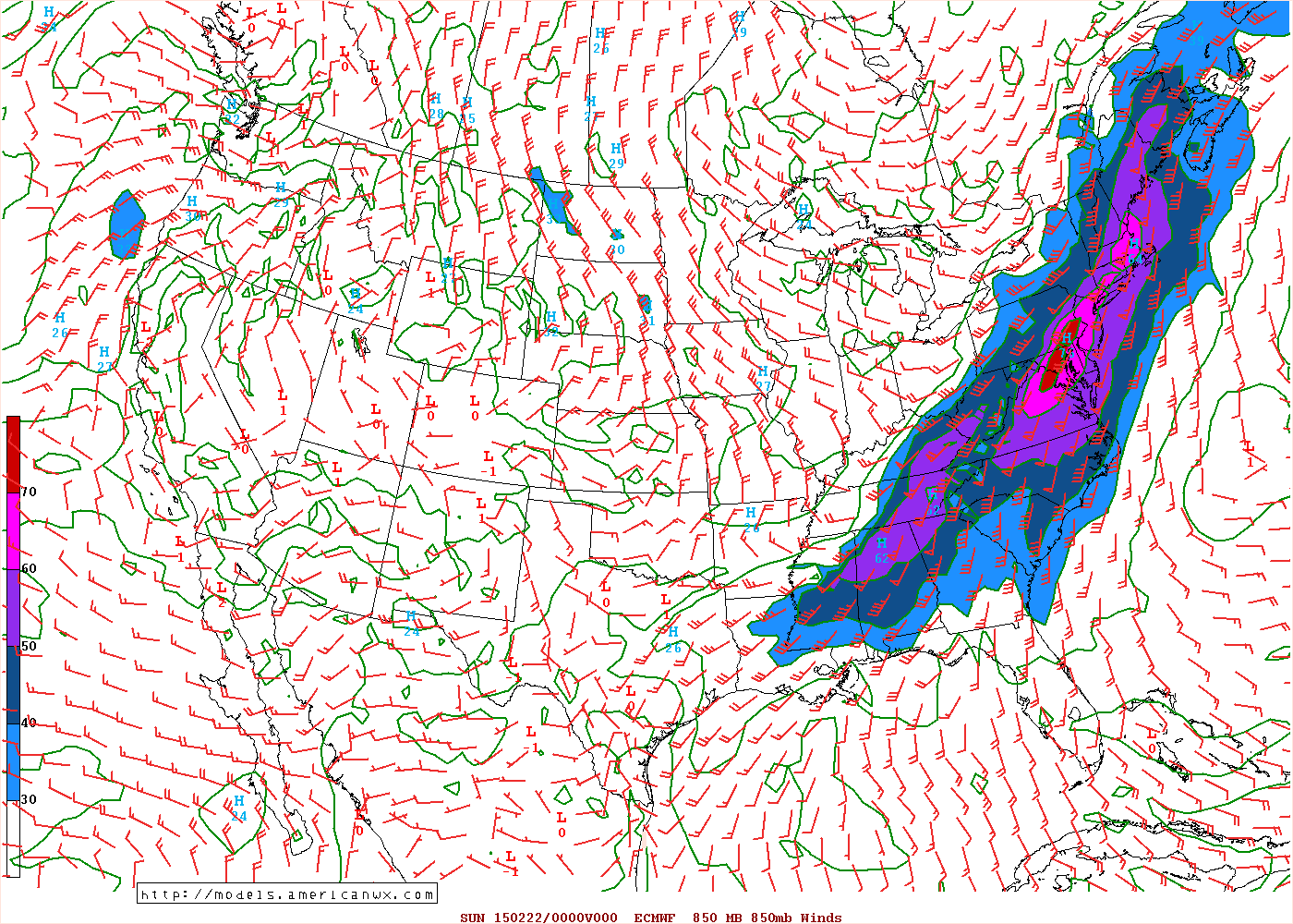
High Impact Winter Storm of February 21
SW Upslope Driven Storm Event
Excessive Snowfall In High Knob Landform
Although there was some S-SSE flow in lowest levels, ROARING SSW-SW winds dominated from around 900 MB upward to drive this event and generate upslope cooling as air was orographically forced to rise from the Tennessee Valley upward through the High Knob Landform into the great, sprawling High Knob Massif and Tennessee Valley Divide ( which includes the Black mountains ).
February 21, 2015 At 7:00 AM
European 16 KM Model 850 MB Wind Field

February 21, 2015 At 7:00 PM
European 16 KM Model 850 MB Wind Field
While I have documented SW Upslope Flow snow events many times in past decades, my analog storm for this event occurred on November 27, 1977 when an early season blast of arctic air was flooded by Gulf of Mexico moisture on strong SW flow in a manner analogous to this event. Snow depths reached 18" in Big Stone Gap and 11" in Wise during 1977.
21" of Mean Snow Depth
7" of New Snow ( 15" To Come )
February 21, 2015 At 8:54 AM
Heavy Snow In High Chaparral
 Photograph by Darlene Fields - © All Rights Reserved.
Roaring SW winds of 30 to 50+ mph created blizzard conditions in the High Knob Massif
where this storm became a beast.
A general 1 to 2 feet of snow was already on the ground before February 21, with deepest snow across northern slopes in the upper elevations. High Chaparral has a southern exposure.
Mean Snow Depth Change
High Chaparral of High Knob Massif
Elevation 3300 feet
14" at 7:00 PM
( February 20 )
21" at 8:54 AM
( February 21 )
31" at 4:00 PM
( February 21 )
36" at 10:30 PM
( February 21 )
Mean snow depths topped 40" on northern slopes in the upper elevations of the massif, with simply huge drifts in places.
The snow depth change was documented on Eagle Knob
by Cody Blankenbecler, with much snow being blown horizontally across the summit prior to this event
during the February 12-19 period.
Elevation 4196 feet
February 21, 2015 At 1:23 AM
Eagle Knob of High Knob Massif
 Image by Cody Blankenbecler - © All Rights Reserved.
Elevation 4196 feet
February 21, 2015 At 3:01 AM
Eagle Knob of High Knob Massif
 Image by Cody Blankenbecler - © All Rights Reserved.
Elevation 4196 feet
February 21, 2015 At 11:10 AM
Eagle Knob of High Knob Massif
 Image by Cody Blankenbecler - © All Rights Reserved.
Elevation 4196 feet
February 21, 2015 At 9:05 PM
Eagle Knob of High Knob Massif
 Image by Cody Blankenbecler - © All Rights Reserved.
*Snow depth in the above view is around waist deep.
Total snow depth was ( as it typically is ) much deeper on northern slopes in adjacent basins holding High Knob Lake, Big Cherry Lake, and the Norton Reservoirs where not only is more deposited but less snow tends to melt-sublimate due to less insolation ( i.e., shady & colder with less sunlight ).
Cal Adams reported waist deep snow at his home just across the Scott County, Va., line adjacent to Big Cherry Lake. Cal was stranded, deep in the high-country, like he had been many times in the 12-years since moving to Little Mountain.
While having plenty of food, Cal was running short on milk & bread. He said it would be nice to have some "sweet milk and a loaf of bread" air dropped in, or flown by military drone if anyone had the means to do the job!
What he really needed, however, was a Dozer to push through HUGE drifts that blocked Route 238.
*The Scott County Police Department called to check on him, which was very nice, but he asked that folks "please don't forget about me."
Updated: Cal was rescued by two Virginia Department of Forestry Dozers which worked to open State Route 619 and Route 237. Cal said, "I want to thank them for saving my life," as he was running out of his medications. He truly was thankful to the VA Department of Forestry!
*Following 6" of new snow into the morning of February 26 Cal said, "I've got 4 FEET of snow on my porch!"
Many private and secondary roads have remained bad to impassible since the February 21 storm, with Joe & Darlene Fields being unable to get out of Lark Road due to 3 feet & more of snow depth.
February 24, 2015 At 12:19 PM
Mountains of Snow Piled High In High Chaparral
Not Boston But High Chaparral of High Knob
 Photograph by Darlene Fields - © All Rights Reserved.
Huge piles of snow have High Chaparral looking like Boston, and little wonder after nearly 5 feet of snow has fallen just during the month of February
( around 6 feet at the summit level as of Feb 26 ).
It has become the snowiest February on record in upper elevations of the High Knob Massif, where more than 70"
have fallen around the summit level during the month.
Once State Route 619 and Route 237 were opened by Virginia Department of Forestry Dozers, snow depth along these roads, amid upper elevations, was reported to be near level with the door handle to lower section of windows, on the driver and passenger sides, of standard 4X4 vehicles.
This was reported by numerous individuals and verified the already documented 40" to 50" snow depths across northern exposed slopes ( 30" to 40" on southern exposed slopes ). Cal Adams said it was certainly true at his home, with "snow depth up to the door handle on my truck."
February 21, 2015 At 1:35 PM
Before 8" Of Additional Snow Depth
View Of 28" From The Doorway
 Photograph by Darlene Fields - © All Rights Reserved.
Cold air that followed all this snow froze it into a SOLID Block hard enough for many to walk on top of, which helped in getting from A to B but made it even harder if you needed to move it out OF the way. Yes, it is true, rock bars & chisels have been used to help move this snow!
February 24, 2015
High Chaparral of High Knob Massif
Mounds Of Snow Frozen Solid Like A Block
 Photograph by Darlene Fields - © All Rights Reserved.
While it might look like Joe is just out in his yard measuring a little snow, he is actually doing that while standing on top of more than 2 feet of snow!
February 24, 2015
Joe Fields Measures New Snow
High Chaparral of High Knob Massif
Standing On Top Of More Than 2 Feet
 Photograph by Darlene Fields - © All Rights Reserved.
Even in lower elevations, upstream of the High Knob Massif, this period was difficult with many added complications due to frozen water lines, blocked roads, and VDOT generated "avalanches" like observed along my road that runs parallel to the state road for several hundred feet.
*The driveway was buried by 2-3 feet or more of snow as
all the snow from the state road was plowed over the bank!
February 2015
VDOT Generated Avalanche
Several Hundred Feet of Driveway Buried
 Photograph by Wayne Browning - © All Rights Reserved.
Don't get me wrong, we are all appreciative of the long, hard hours that VDOT puts in during such extended periods of severe weather.
February 2015
VDOT Plowing Snow In Wise County, Virginia
 Photograph by Roddy Addington - © All Rights Reserved.
One of the most dangerous and damaging aspects of this harsh February of record snowfall was build up of snow loads, which reached critical values in many places with dozens of collapsed structures in counties along the mountainous Virginia-Kentucky stateline ( Wise County being among the hardest hit ).
February 2015 in Wise County, Virginia
Morgan-McClure In The Town of Coeburn
Classic Cars Destroyed By Building Collapse
 Photograph by Roddy Addington - © All Rights Reserved.
My friend & photographer Roddy Addington captured one of the most expensive losses as a building containing classic cars in the Town of Coeburn collapsed under the heavy snow load
( water weight ).
February 2015 in Wise County, Virginia
Morgan-McClure In The Town of Coeburn
Classic Cars Destroyed By Building Collapse
 Photograph by Roddy Addington - © All Rights Reserved.
While a building collapse on classic cars made TV news, the dozens and dozens of other structures which collapsed were just as important to those impacted by the damage.
February 2015 in Wise County, Virginia
Morgan-McClure In The Town of Coeburn
Classic Cars Destroyed By Building Collapse
 Photograph by Roddy Addington - © All Rights Reserved.
These collapses occurred across the area.
February 2015
Collapse From Snow Load Weight
Private Home Damage In Wise County, Virginia
 Photograph by Roddy Addington - © All Rights Reserved.
Many private and commercial structures
were impacted.
February 2015
Town of Wise, Virginia
Damage From Snow Load In Downtown Wise
 Photograph by Roddy Addington - © All Rights Reserved.
The best photograph Rod took during this event was of a kid shoveling snow, with the expression on this child's face saying it all about record snowfall in February 2015!
February 2015
Wise County, Virginia
Kid's Face Says It All About Record Snow
 Photograph by Roddy Addington - © All Rights Reserved.
There can always be too much of anything!
February 2015
Car Buried By Snow In Wise County, Virginia
 Photograph by Roddy Addington - © All Rights Reserved.
Water equivalent precipitation totals were significant amid the lifting zone of the High Knob Massif with 6.33" at the City of Norton Water Plant and 6.23" at Appalachia Lake Water Plant, along northern bases of the massif, and approximately 8.07" at Big Cherry Dam in the high country.
*Great orographic enhancement occurred with SW upslope flow when nearly all snow fell above 3000 feet in the High Knob Massif area during February 20-21 ( 20" to 30" of new snowfall ).
Reference My Appalachian Climate Center
for more specific climate details.
High Knob Massif - March 9, 2015
Looking SW Across Big Cherry Lake Basin
 Photograph by Wayne Browning - © All Rights Reserved.
*The 8.07" being based upon snow core data and reported snow depths, as well as partial rain gauge catches which could not begin to hold all the deep snow ( 5-6 feet ).
The general 40-50" on northern exposed slopes
( NW-N-NE ), 30-40" on southern exposed slopes, were the greatest snow depths reported across the southern Appalachians during February 2015.
February 22, 2015
Powell River of Upper Tennessee Basin
Cumberland Mountain of High Knob Landform
Winter Panorama In Wilderness Road State Park
 Photograph by Harold L. Jerrell - © All Rights Reserved.
Despite the harsh nature of February 2015, there was simply no denying the great beauty that also came with record snowfall in the Cumberlands.
Lee County, Virginia
February 24, 2015 at 5:27 PM
White Rocks of Cumberland Mountain
Deep Snow In Valley Beneath The White Rocks
 Photograph by Harold L. Jerrell - © All Rights Reserved.
Certainly a February that
will not be soon forgotten.
Lee County, Virginia
February 21, 2015 at 12:41 PM
New Snow On Car In Silver Leaf Community
 Photograph by Harold L. Jerrell - © All Rights Reserved.
High Impact Winter Storm of February 21
SW Upslope Driven Storm Event
Excessive Snowfall In High Knob Landform
Although there was some S-SSE flow in lowest levels, ROARING SSW-SW winds dominated from around 900 MB upward to drive this event and generate upslope cooling as air was orographically forced to rise from the Tennessee Valley upward through the High Knob Landform into the great, sprawling High Knob Massif and Tennessee Valley Divide ( which includes the Black mountains ).
February 21, 2015 At 7:00 AM
European 16 KM Model 850 MB Wind Field

February 21, 2015 At 7:00 PM
European 16 KM Model 850 MB Wind Field

While I have documented SW Upslope Flow snow events many times in past decades, my analog storm for this event occurred on November 27, 1977 when an early season blast of arctic air was flooded by Gulf of Mexico moisture on strong SW flow in a manner analogous to this event. Snow depths reached 18" in Big Stone Gap and 11" in Wise during 1977.
21" of Mean Snow Depth
7" of New Snow ( 15" To Come )
February 21, 2015 At 8:54 AM
Heavy Snow In High Chaparral

Roaring SW winds of 30 to 50+ mph created blizzard conditions in the High Knob Massif
where this storm became a beast.
A general 1 to 2 feet of snow was already on the ground before February 21, with deepest snow across northern slopes in the upper elevations. High Chaparral has a southern exposure.
Mean Snow Depth Change
High Chaparral of High Knob Massif
Elevation 3300 feet
14" at 7:00 PM
( February 20 )
21" at 8:54 AM
( February 21 )
31" at 4:00 PM
( February 21 )
36" at 10:30 PM
( February 21 )
Mean snow depths topped 40" on northern slopes in the upper elevations of the massif, with simply huge drifts in places.
The snow depth change was documented on Eagle Knob
by Cody Blankenbecler, with much snow being blown horizontally across the summit prior to this event
during the February 12-19 period.
Elevation 4196 feet
February 21, 2015 At 1:23 AM
Eagle Knob of High Knob Massif
Elevation 4196 feet
February 21, 2015 At 3:01 AM
Eagle Knob of High Knob Massif
Elevation 4196 feet
February 21, 2015 At 11:10 AM
Eagle Knob of High Knob Massif
Elevation 4196 feet
February 21, 2015 At 9:05 PM
Eagle Knob of High Knob Massif
*Snow depth in the above view is around waist deep.
Total snow depth was ( as it typically is ) much deeper on northern slopes in adjacent basins holding High Knob Lake, Big Cherry Lake, and the Norton Reservoirs where not only is more deposited but less snow tends to melt-sublimate due to less insolation ( i.e., shady & colder with less sunlight ).
Cal Adams reported waist deep snow at his home just across the Scott County, Va., line adjacent to Big Cherry Lake. Cal was stranded, deep in the high-country, like he had been many times in the 12-years since moving to Little Mountain.
While having plenty of food, Cal was running short on milk & bread. He said it would be nice to have some "sweet milk and a loaf of bread" air dropped in, or flown by military drone if anyone had the means to do the job!
What he really needed, however, was a Dozer to push through HUGE drifts that blocked Route 238.
*The Scott County Police Department called to check on him, which was very nice, but he asked that folks "please don't forget about me."
Updated: Cal was rescued by two Virginia Department of Forestry Dozers which worked to open State Route 619 and Route 237. Cal said, "I want to thank them for saving my life," as he was running out of his medications. He truly was thankful to the VA Department of Forestry!
*Following 6" of new snow into the morning of February 26 Cal said, "I've got 4 FEET of snow on my porch!"
Many private and secondary roads have remained bad to impassible since the February 21 storm, with Joe & Darlene Fields being unable to get out of Lark Road due to 3 feet & more of snow depth.
February 24, 2015 At 12:19 PM
Mountains of Snow Piled High In High Chaparral
Not Boston But High Chaparral of High Knob

Huge piles of snow have High Chaparral looking like Boston, and little wonder after nearly 5 feet of snow has fallen just during the month of February
( around 6 feet at the summit level as of Feb 26 ).
It has become the snowiest February on record in upper elevations of the High Knob Massif, where more than 70"
have fallen around the summit level during the month.
Once State Route 619 and Route 237 were opened by Virginia Department of Forestry Dozers, snow depth along these roads, amid upper elevations, was reported to be near level with the door handle to lower section of windows, on the driver and passenger sides, of standard 4X4 vehicles.
This was reported by numerous individuals and verified the already documented 40" to 50" snow depths across northern exposed slopes ( 30" to 40" on southern exposed slopes ). Cal Adams said it was certainly true at his home, with "snow depth up to the door handle on my truck."
February 21, 2015 At 1:35 PM
Before 8" Of Additional Snow Depth
View Of 28" From The Doorway

Cold air that followed all this snow froze it into a SOLID Block hard enough for many to walk on top of, which helped in getting from A to B but made it even harder if you needed to move it out OF the way. Yes, it is true, rock bars & chisels have been used to help move this snow!
February 24, 2015
High Chaparral of High Knob Massif
Mounds Of Snow Frozen Solid Like A Block

While it might look like Joe is just out in his yard measuring a little snow, he is actually doing that while standing on top of more than 2 feet of snow!
February 24, 2015
Joe Fields Measures New Snow
High Chaparral of High Knob Massif
Standing On Top Of More Than 2 Feet

Even in lower elevations, upstream of the High Knob Massif, this period was difficult with many added complications due to frozen water lines, blocked roads, and VDOT generated "avalanches" like observed along my road that runs parallel to the state road for several hundred feet.
*The driveway was buried by 2-3 feet or more of snow as
all the snow from the state road was plowed over the bank!
February 2015
VDOT Generated Avalanche
Several Hundred Feet of Driveway Buried

Don't get me wrong, we are all appreciative of the long, hard hours that VDOT puts in during such extended periods of severe weather.
February 2015
VDOT Plowing Snow In Wise County, Virginia

One of the most dangerous and damaging aspects of this harsh February of record snowfall was build up of snow loads, which reached critical values in many places with dozens of collapsed structures in counties along the mountainous Virginia-Kentucky stateline ( Wise County being among the hardest hit ).
February 2015 in Wise County, Virginia
Morgan-McClure In The Town of Coeburn
Classic Cars Destroyed By Building Collapse

My friend & photographer Roddy Addington captured one of the most expensive losses as a building containing classic cars in the Town of Coeburn collapsed under the heavy snow load
( water weight ).
February 2015 in Wise County, Virginia
Morgan-McClure In The Town of Coeburn
Classic Cars Destroyed By Building Collapse

While a building collapse on classic cars made TV news, the dozens and dozens of other structures which collapsed were just as important to those impacted by the damage.
February 2015 in Wise County, Virginia
Morgan-McClure In The Town of Coeburn
Classic Cars Destroyed By Building Collapse

These collapses occurred across the area.
February 2015
Collapse From Snow Load Weight
Private Home Damage In Wise County, Virginia

Many private and commercial structures
were impacted.
February 2015
Town of Wise, Virginia
Damage From Snow Load In Downtown Wise

The best photograph Rod took during this event was of a kid shoveling snow, with the expression on this child's face saying it all about record snowfall in February 2015!
February 2015
Wise County, Virginia
Kid's Face Says It All About Record Snow

There can always be too much of anything!
February 2015
Car Buried By Snow In Wise County, Virginia

The final snowfall numbers were significant.
February 2015 Snowfall Totals
Dungannon In Clinch River Valley: 26.4"
Clintwood 1 W: 30.4"
Big Stone Gap WWTP: 32.0"
Norton Water Plant: 40.0"
Wise 3 E: 41.7"
High Chaparral of High Knob Massif: 56.0"
Crest Zone of High Knob Massif: 73.0"
Water equivalent precipitation totals were significant amid the lifting zone of the High Knob Massif with 6.33" at the City of Norton Water Plant and 6.23" at Appalachia Lake Water Plant, along northern bases of the massif, and approximately 8.07" at Big Cherry Dam in the high country.
*Great orographic enhancement occurred with SW upslope flow when nearly all snow fell above 3000 feet in the High Knob Massif area during February 20-21 ( 20" to 30" of new snowfall ).
Reference My Appalachian Climate Center
for more specific climate details.
High Knob Massif - March 9, 2015
Looking SW Across Big Cherry Lake Basin

*The 8.07" being based upon snow core data and reported snow depths, as well as partial rain gauge catches which could not begin to hold all the deep snow ( 5-6 feet ).
The general 40-50" on northern exposed slopes
( NW-N-NE ), 30-40" on southern exposed slopes, were the greatest snow depths reported across the southern Appalachians during February 2015.
February 22, 2015
Powell River of Upper Tennessee Basin
Cumberland Mountain of High Knob Landform
Winter Panorama In Wilderness Road State Park

Despite the harsh nature of February 2015, there was simply no denying the great beauty that also came with record snowfall in the Cumberlands.
Lee County, Virginia
February 24, 2015 at 5:27 PM
White Rocks of Cumberland Mountain
Deep Snow In Valley Beneath The White Rocks

Certainly a February that
will not be soon forgotten.
Lee County, Virginia
February 21, 2015 at 12:41 PM
New Snow On Car In Silver Leaf Community


